Views sought on future use of Guernsey waters

 BBC
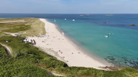
BBCPeople have been invited to share their views on the future use of Guernsey's territorial waters.
The survey by the Committee for the Environment & Infrastructure asks people about what Guernsey waters mean to them, how they are used, and their future use.
The information will be used to help shape a draft Marine Spatial Plan setting out a long term vision for Guernsey's marine environment.
Deputy Sally Rochester, committee vice president, said the survey aimed to balance the needs of the public against other boaters, fishers and developers.
'Future generations'
Rochester said: "Our seas play a huge role in our quality of life and in the economic success of our islands.
"We also know that protecting and regenerating our marine habitats is critical for future generations of islanders.
"We are working on a marine spatial plan to balance these important factors."
The plan will cover Guernsey's territorial waters out to 12 nautical miles, including the waters around Herm.
This area covers about 700 sq miles (1812.99 sq km) which is about 10 times the size of Guernsey's landmass.
The committee said the survey would be the first of two opportunities for members of the public to have their say.
There will also be workshops and focus groups with specific groups and individuals over the coming weeks.
Rochester said: "Our territorial waters represent an incredible opportunity and untapped potential which, with our community's input, can benefit our community both now and for years to come."
The survey closes on Friday, 12 June.
Follow BBC Guernsey on X and Facebook and Instagram. Send your story ideas to channel.islands@bbc.co.uk.
