'Citizen scientist' photos used to reduce flooding

 Citizen scientists/Sheffield and Rotherham Wildlife Trust
Thousands of photos taken by Sheffield's walkers and runners are being used to help monitor water management and flood risk as part of an environmental project.
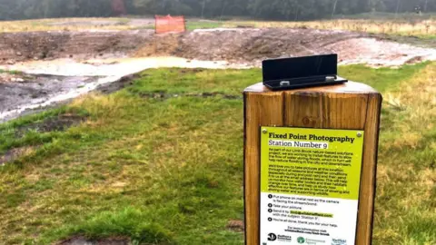
The scheme, led by Sheffield & Rotherham Wildlife Trust and the Environment Agency, asked people to take photos at 15 set locations and send them to be analysed.
The aim was to identify any issues in the Limb Brook catchment which could lead to flooding if action was not taken, with more than 4,500 photos collected over 26 months.
The success of the project so far means it will be extended, with new photography locations put forward for the public to capture.
A new study by Sheffield Hallam University which evaluated the project found that the involvement of "citizen scientists" can be of valuable help.
Co-author of the study, Mel Lacey, said: "Stopping for a few seconds to take and submit a photo on your walk sounds like such a small action, but members of the public getting involved in supporting their local environment is helping the project team make their work more efficient and effective."
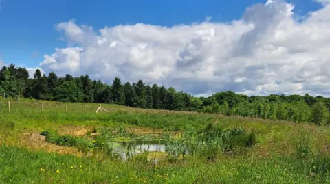
Over a period of two years, "nature-based solutions" aiming to reduce flooding were captured in photos across Lady Canning's Plantation, Limb Brook Valley and Whirlow Fields.
These solutions include leaky dams and attenuation ponds – features which are designed to help slow the flow of excess water from rain and storms.
The natural techniques in the catchment limit the amount of water making its way into the River Don and reduce the risk of flooding in parts of Sheffield and even further afield in Rotherham and Doncaster, those behind the study said.
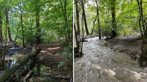
According to Lacey, an associate professor from Sheffield Hallam University's School of Biosciences and Chemistry, the photos identified the failure of a leaky dam that was washed away during Storm Babet in October 2023.
"The data provided by the public was able to show the dam had previously slowed the speed and reduced the flow of flood water downstream during three previous storms, but rare and high-risk flooding events could dislodge and wash it away," she said.
 Citizen scientists/Sheffield and Rotherham Wildlife Trust
Researchers produced a system to automatically analyse public contributions, sorting them by location and date.
Adding rainfall data allowed the project team to observe real-time changes in the environment.
Martin Reed, environmental adviser from the Sheffield & Rotherham Wildlife Trust, said: "These photos provide a clear record of how the landscape has matured - from ponds becoming lush with vegetation to leaky dams reshaping the channel."
 Sheffield and Rotherham Wildlife Trust
Jackie Lowe, from the Environment Agency, said: "This paper has been a productive collaboration, adding value to both practical work in the field and academic research.
"The partners involved in delivery of the project are now incorporating recommendations from the research and extending this learning to similar projects across our region."
Listen to highlights from South Yorkshire on BBC Sounds, catch up with the latest episode of Look North
