Quick version
Volcanoes are found at:
- Divergent plate boundaries - where plates are moving away from each other.
- Convergent plate boundaries - where plates are pushing into each other.
- Hotspots - where columns of rising magma melt and weaken the crust.
Volcanic eruptions are unpredictable but scientific monitoring can identify signs that an eruption is likely to occur:
- increases in gas emissions
- change in volcano's shape
- increased seismic activity
- increased thermal activity
The threat of an eruption and its impact can be minimised:
- evacuation plans put in place
- exclusion zones keep people out of dangerous areas, or prevent building in areas at risk
- volcanic alert systems notify people of potential or ongoing eruptions
Video - Volcanoes
Watch this video to revise the key points about volcanoes in the Environmental Hazards section of National 5 Geography.
The earth has three layers: the core, the mantle and the crust.
A volcano occurs when magma from the mantle breaks through the crust, reaching the Earth's surface, erupting and forming lava.
The crust is broken into tectonic plates floating on the moving molten rock in the mantle.
These plates collide and separate at boundaries, sometimes creating volcanoes.
Magma is pushed up from the chamber of a volcano and through vents erupting as lava from the crater.
Volcanic activity can have positive effects, like providing geothermal energy and ash that fertilises the soil.
But volcanoes can harm people and landscapes.
Landslides and pyroclastic flows destroy the environment, wiping out farmlands and ecosystems.
As a result, people face loss of livelihood, destruction of towns and cities, and death.
For example, the 1902 eruption of Mount Pelee completely destroyed the city of Saint-Pierre in Martinique, killing 29,000 people.
According to reports at the time, it erupted without warning.
Predicting volcanic eruptions is complex.
Scientists measure gas emissions and changes to a volcano’s shape, and monitor for increased seismic or thermal activity.
All are warning signs that an eruption might be on the way.
Despite technological advances, predicting the precise timing and nature of eruptions remains full of uncertainty.
Management plans can include evacuations, exclusion zones and emergency protocols such as warnings following volcano monitoring.
As seen on the Canary Islands during the Cumbre Vieja eruption in 2021, plans can be put in place to allow the rapid evacuation of residents, but large scale management plans remain largely untested, so their effectiveness is unknown.
Where do volcanoes form?
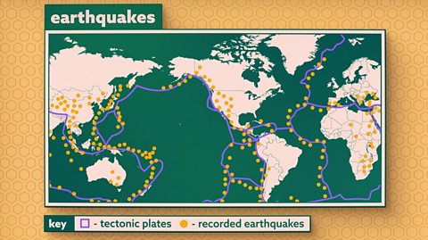
Volcanoes usually form along plate boundaries, where A section of the Earth’s crust, the outer shell of the Earth. are either moving towards or away from one another:
- Divergent plate boundaries - also called a constructive plate boundary, where plates are moving away from each other, for example Iceland.
- Convergent plate boundaries - also called a destructive plate boundary, where plates are pushing into each other, for example Mount St Helens in the USA.
Volcanoes can also form away from plate boundaries over A hotspot occurs when there is intense heat in the mantle which rises towards the crust. When the melted rock (magma) reaches the surface it creates volcanoes, eg the Hawaiian islands., for example the Canary Islands or Hawaiian Islands.
Over 450 of the world’s active and dormant volcanoes (around 75%) are located around the Pacific Ring of Fire which runs around the Pacific Ocean, passing through a number of countries including Japan, New Zealand and Mexico.
Volcanoes formed on constructive plate boundaries
When two plates move apart, the cracks in the crust allow liquid rock, called Molten rock., to rise from the The middle layer of the Earth's structure. The mantle lies between the Earth's core and the crust. This is the thickest layer of the Earth and is mostly made of solid rock, with some softer, very slowly flowing rock deeper down near the core. through the The crust is the outer layer of the Earth on which we live. It is the thinnest layer and is between 5 and 90 km thick., to the surface.
When this molten rock reaches the surface it is called a volcanic eruption.
Volcanoes on destructive plate boundaries
- Destructive plate boundaries involve two plates moving towards each other.
- The heavier plate is subducted (forced down below the lighter plate), into the The middle layer of the Earth's structure. The mantle lies between the Earth's core and the crust. This is the thickest layer of the Earth and is mostly made of solid rock, with some softer, very slowly flowing rock deeper down near the core., where it melts.
- The molten rock rises up to the surface through cracks in the rocks creating a volcanic eruption.
- These eruptions are usually very explosive because they are mixed with gases.
Volcanoes on hot spots
A hot spot is a place where a static column of rising magma occurs in the mantle. This magma plume is hotter than the mantle around it.
The magma pushes up the crust above it creating a dome. The crust weakens and can eventually crack resulting in a volcanic eruption.
As the tectonic plate moves over the hot spot, a chain of volcanoes or volcanic islands can form, for example the Canary Islands or Hawaiian Islands.
What are the main features of volcanoes?
- Magma at the surface is called lava and it cools and solidifies into solid rock.
- This process can repeat itself over many years forming a cone-shaped mountain or volcano.
Volcanoes have common features:
- magma chamber - this is where the molten rock is stored beneath the ground at great heat and pressure
- main vent - the channel through which magma rises to reach the Earth's surface
- secondary vent - some magma may escape through the side of the volcano, particularly if the main vent becomes blocked
- crater - this is found at the top of the volcano and the magma usually erupts from here
- cone - this is formed from the material ejected during eruptions and grows in size with each eruption
When a volcano erupts there can be lava, ash, steam or gaseous emissions:
- lava flow - lava is the name for magma that has reached the Earth's surface. Laval flows are rivers of molten rock that flow down the sides of a volcano.
- ash cloud - in an explosive eruption, dissolved gases expand, breaking the magma into tiny particles of rock and glass. These rise up into the air as a cloud.
- pyroclastic flow - a fluid mix of of hot steam, ash, rock, volcanic gases and dust. This hugs the ground and flows at very high speed down the sides of a volcano.
- sometimes eruptions are explosive and lava is thrown out as volcanic bombs.
Predicting and planning for volcanic eruptions
Countries can try to reduce the risk of damage from volcanic eruptions by attempting to predict when they might occur, protecting their buildings and preparing their population for what to do in the event of an eruption.
The extent to which a country can do this depends on their level of development.
- A high income country like Iceland can spend more than a low income country like Democratic Republic of Congo, meaning the effects would be reduced more.
Prediction
Volcanic eruptions are unpredictable, so volcanoes can be monitored to estimate when and where they are likely to erupt. A variety of techniques are used:
| measurement | equipment | indicator of eruption |
|---|---|---|
| gas emissions | spider robots | increase in gases like sulfur dioxide |
| change in landscape | tiltmeters, GPS, lasers | swelling of volcano or change in shape |
| seismic activity | seismometer | increase in ground movement and earth tremors |
| temperature | thermometers | increase in temperature can show rise in magma inside volcano |
Planning
The threat of an eruption and its impact can be minimised:
- exclusion zones can be put in place to keep people away when there is a threat of eruption. Longer term exclusion zones can prevent buildings from being constructed in areas as possible risk of eruptions.
- evacuation plans are put in place so that people know the safest routes away from danger.
- volcanic alert systems notify people of potential or ongoing eruptions.
- survival kits - people are encouraged to put together kits with bottled water, non-perishable foods, face masks and a battery-powered radio
Measures can be taken during an eruption to minimise danger and damage:
- Bulldozers and diggers can be used to create earth barriers to redirect lava flows away from buildings and infrastructure.
- Spraying water onto lava is used to cool it, so that it becomes more solid and slower.
- Flights can be stopped or diverted to prevent aircraft being endangered or damaged by ash clouds.
Case study: Cumbre Vieja, 2021
The Cumbre Vieja eruption took place on La Palma, one of the Canary Islands, which lie in the Atlantic Ocean.
The Canary Islands are an autonomous region of Spain.
The Cumbre Vieja volcano on La Palma erupted from the 19th September to the 13th December 2021.
Causes
The Canary Islands have over 30 volcanoes, ten of which lie on the island of La Palma.
The volcanoes are located above a hot spot rather than along a plate boundary.
The Canary Island hot spot is located on the African plate, which is estimated to be moving between 2cm to 3cm per year.
Before the eruption
Multiple earthquakes were detected in early September 2021. These were caused by the force of magma moving upwards and fracturing the crust.
Monitoring this seismic activity showed the focuses of earthquakes had risen from a depth of 20 km to just a few kilometres. This showed how close the magma was to the surface.
Satellites and GPS showed the landscape had changed shape, rising by up by 15 cm.
- Image source, Europa Press News / getty images
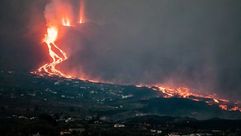
Image caption, Cumbre Vieja volcano expelling lava and pyroclast, forcing 7,000 people to evacuate.
1 of 2
Impact of the eruption
The volcanic eruption began on 19th September, releasing columns of gas and pyroclasts, and flows of lava. The eruption continued until 13th December:
- Rather than one crater, emissions came from 33 separate fissures during the course of the eruption.
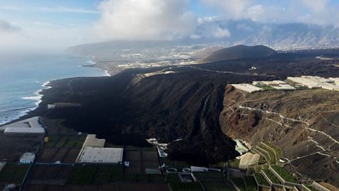
- A new volcano (called Tajogaite) nearly 200 m high and 700 m in diameter was built up.
- The column of gas and ash above the eruption reached up to 8.5 km above sea level.
- Ash from the eruption reached other Canary Islands, including Tenerife and Gran Canaria, up to 200 km away.
- Lava flows covered over 12 km² of land
- Around 10 km^2 of farmland, including 4 km² of banana plantations were destroyed, damaging the economy of the island.
- More than 7,000 people had to leave their homes.
- 2,800 buildings were destroyed, including over 1,000 homes, factories, a church and school.
- One man died due to inhaling toxic gases while in the exclusion zone.
- Spanish authorities estimated the direct cost of the eruption was €862.7 million.
Management
- Scientific monitoring allowed the Canary Island Volcano Emergency Plan (PEVOLCA) to be activated before the eruption.
- This allowed the rapid evacuation of 300 people in the local area
- Monitoring of the lava flow showed that possible blocking of a major highway, leading to the evacuation of a further 700 people from the Los Llanos de Aridane coastal region.
- A exclusion zone of 2.5 km around the centre of the eruption was established to protect people from pyroclastics and volcanic gases.
- The hospital in La Palma cancelled routine activity to be ready to take on emergency treatment, although this was not needed.
- Flights to and from the island were halted to prevent ash clouds from damaging planes or causing engine failure.
- After an increase in gas emissions in December, 33,000 people were ordered to stay indoors.
- In early 2022, €5.4 million from the EU Solidarity Fund (EUSF) was paid to Spain to cover costs of immediate emergency and recovery work.
Case study: Mt. St Helens 1980
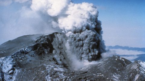 Image source, GRANGER - Historical Picture Archive / Alamy Stock Photo
Causes
Mount St. Helens, Washington State, began a series of eruptions in 1980 when a massive When a mass of rock, debris, or earth moves down a slope. and powerful explosive eruption created a large crater, and ended six years later after more than a dozen eruptions of lava built a dome in the crater.
The first sign of activity began in the spring of 1980 with a series of small earthquakes began. After thousands of additional earthquakes and steam explosions, a cataclysmic eruption occurred on 18 May 1980.
Mount St Helens lies close to a destructive plate boundary where the smaller Juan de Fuca plate is being forced into the mantle by the larger North American plate.
Friction and heat cause the plate to melt and, as it melts, molten rocks are formed. The molten rock builds up until it has the chance to reach the surface through cracks in the Earth’s crust.
Before the eruption
Beginning in March 1980, an increasing number of small earthquakes were recorded by seismographs. The earthquakes became more frequent and some were more severe.
Eruptions of steam began from the main crater in late March.
A bulge began to form on the north face of the mountain, reaching over 2.4 km in diameter.
Scientists predicted correctly that the growing bulge would cause a landslide that would weaken the mountain and lead to an eruption.
A state of emergency was declared and authorities were able to evacuate people from the areas surrounding Mount St Helens, and they set up an An area where people are not permitted to be. around the volcano. Emergency services were also on hand to rescue those people needing help.
Impact of the eruption
The mountain was reduced from a height of 2950m to 2560m as the eruption created the largest landslide ever recorded.
All plant and animal life within a 25km radius of the volcano was killed, including fully grown trees.
Mudflows poured down the valleys choking rivers with rock debris, killing fish and ripping trees from their roots.
Sixty one people died due to mudflows, being crushed to death and poisonous gases, while 198 had to be rescued.
Mudflows destroyed bridges, houses and logging camps.
The explosion flattened buildings and trees and knocked out power supplies and telephones.
Ash clouds resulted in airline flights being cancelled.
Ash caused £100 million of damage to farm machinery and crops.
Video - The sleeping giant
In this video clip, Professor Iain Stewart tells the story of Mount St Helens' 1980 eruption.
An earthquake-triggered landslide unleashed a sideways blast of hot gas and ash from this famous stratovolcano volcano (also known as a composite volcano) in the state of Washington, USA.
Professor Iain Stewart tells the story of Mount St Helens' 1980 eruption.
Professor Iain Stewart
This is Mount St Helens. At the beginning of 1980, the mountain stood alone - an elegant, symmetrical cone. A perfect example of what's known as a stratovolcano.
Over the last four and a half thousand years, St Helens had grown to a height of ten thousand feet. But this beautiful symmetry wasn't to last. A tranquil setting for camping and hiking, St Helens was a beauty spot, popular with nature lovers. A picturesque lake to the North was popular for fishing and was known as Spirit Lake for its legendary moaning noises. Legend or not, after over one hundred years of stillness, Mount St Helens rumbled to life.
Interviewee
One of the guys came running downstairs saying that there had been a magnitude four earthquake reported by one of the permanent manned observeratories used at the mountains, somewhere in western Washington and we spent about fifteen or twenty minutes ascertaining that the earthquake had been at Mount St Helens.
Professor Iain Stewart
The awakening of the sleeping giant increased its draws of tourist attraction. Earthquakes and minor eruptions had people flocking to watch the show. It wasn't clear exactly what the volcano was going to do next. Erring on the side of caution, the authorities set up exclusion zones in an attempt to keep the public out of harm's way. But the information wasn't precise enough and people grew impatient. News reporters wanted the best view, loggers wanted to keep working and some of the locals refused to leave their homes.
Local
No, I won't leave. I won't leave. They'll have to take me out here. They'll come and get me, they better not come get me. They'll get this [incoherent] if they come get Truman.
Professor Iain Stewart
Perhaps it was the volcano's location in a world superpower that gave residents and visitors alike a false sense of their own security. Geologists watching the mountain observed a bulge on its upper north slope. Due to a build up of magma beneath its surface, the bulge was growing like a blister by five feet each day. But what no one imagined was what the growing bulge was going to do.
Interviewee
It could be within hours, it could be within days or even up to a couple of months. This is not a good spot to be standing in.
Professor Iain Stewart
Then on the 18th of May, Mount St Helens took everybody by surprise. It erupted, but it erupted sideways. What scientists believe happened was that an earthquake triggered the biggest landslide in recorded history. It roared down the north face of the mountain at over one hundred and fifty miles an hour. This in turn caused the blister on the side of the mountain to burst, releasing a huge blast of a volcano's most infamous and terrifying weapon: pyroclastic flow. This surge of hot gas, ash and rock blasted out of the mountain at over three hundred miles an hour. Reaching temperatures of three hundred fifty degrees C, the blast devastated an area two hundred thirty miles square.
Take the National 5 Geography Volcanoes quiz
Recap
Volcanoes are found at:
- Divergent plate boundaries - also called a constructive plate boundary, where plates are moving away from each other.
- Convergent plate boundaries - also called a destructive plate boundary, where plates are pushing into each other.
- Hot spots - where columns of rising magma melt and weaken the crust.
Volcanic eruptions are unpredictable but scientific monitoring can identify signs that an eruption is likely to occur:
- increases in gas emissions
- change in volcano's shape
- increased seismic activity
- increased thermal activity
The threat of an eruption and its impact can be minimised:
- evacuation plans put in place
- exclusion zones keep people out of dangerous areas, or prevent building in areas at risk
- volcanic alert systems notify people of potential or ongoing eruptions
- building more eruption-resistant buildings
- earth barriers can be built to divert lava flow away from buildings and infrastructure
- water can be sprayed onto the advancing lava to cool it and slow its movement
- flights can be stopped or diverted away from ash clouds that could damage aircraft.
More on Environmental hazards
Find out more by working through a topic
- count3 of 3
- count1 of 3