Quick version
Earthquakes are mainly found on the boundaries of tectonic plates.
The main features of an earthquake are:
- fault line
- plate movement
- epicentre
- focus
- seismic waves
Earthquakes are caused by the sudden movement of tectonic plates which make up the Earth's crust.
Predicting earthquakes:
- tiltmeters, seismographs and laser equipment monitor earth movements
- sound recording equipment to monitor earth tremors
Planning for earthquakes:
- constructing earthquake-proof buildings
- practising earthquake drills
- modern communication and warning systems
Video - Earthquakes
Watch this video to find out about the causes and impact of earthquakes, and how they can be mitigated against.
Earthquakes are violent ground movements that occur near tectonic plate boundaries, releasing immense energy.
The sudden shift of rocks inside the Earth's crust creates intense pressure, unleashing shock waves in all directions.
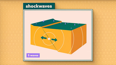
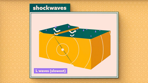
P waves make rocks move vertically, S waves cause side to side motion, and L waves, the most destructive of all, spread out along the surface.
The epicentre, directly above the earthquake's origin, suffers the most.
Earthquakes disproportionately affect developing countries.
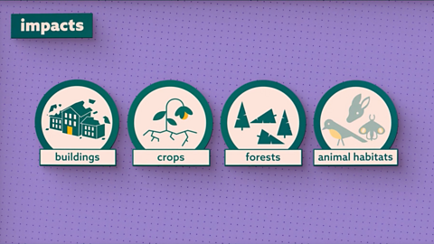
The impacts are severe, including the destruction of buildings, crops, forests and animal habitats.
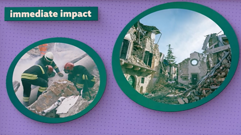
The immediate impact on people is death and injury from collapsing buildings, made worse by additional damage caused by aftershocks.
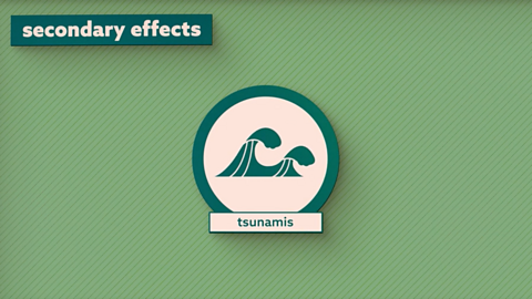
Further devastation is caused by the secondary effects of an earthquake, such as tsunamis, as seen in the 2004 Indian Ocean earthquake and tsunami.
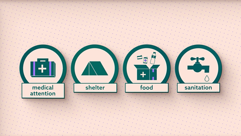
Following an earthquake, immediate aid focuses on rescue efforts and meeting basic needs.
This includes medical attention, shelter, food and sanitation, as damaged water pipes and sewage systems can spread disease.
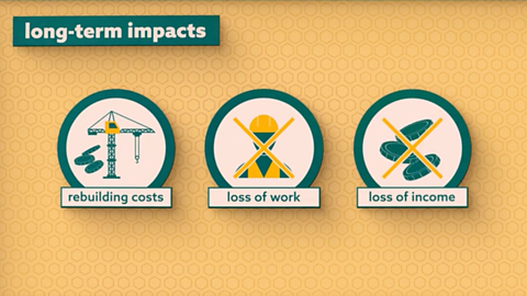
Long term impacts include rebuilding costs, along with loss of work and income for both individuals and entire regions.
To limit the impact, short term emergency procedures include regular earthquake drills in schools and workplaces, and tsunami warning systems.
Householders are also advised to have earthquake survival kits ready.
Long term strategies include building earthquake proof structures and seawalls to protect against tsunamis, but these are expensive.
In regions with less money to invest in earthquake resistant buildings and detection methods, the damage is even worse.
In 2005, an earthquake affecting Pakistan, Afghanistan and India caused a huge death toll.
Other long term strategies include monitoring with seismometers and geological surveys, but accurately predicting earthquakes remains challenging.
Location of earthquakes
Earthquakes are mainly found along the boundaries of A section of the Earth’s crust, the outer shell of the Earth. as shown on the map below.
There is a band of earthquakes, known as the Pacific Ring of Fire, which runs all the way around the Pacific Ocean, passing through a number of countries, eg Japan.
The west coasts of North and South America are in earthquake zones as is the mid-Atlantic ridge and the southern Mediterranean around Turkey and Italy.
Causes of earthquakes
Earthquakes are caused by the sudden movement of tectonic plates which make up the Earth's crust.
- The edges of tectonic plates are uneven and rough so they do not slide smoothly against each other.
- When tectonic plates move against each other they can become stuck because of friction
- The forces moving the plates continue to push them. This leads to a build-up of pressure.
- Eventually the forces become too great and the plates suddenly jolt and move.
- The built up energy is released as seismic waves which cause the earth to shake violently.
- This shaking movement is an earthquake.
Seismic waves
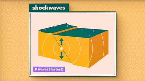
Image caption, P waves
P waves make rocks move vertically
1 of 3
The main features of earthquakes
The main features of an earthquake are:
- fault line - Where one tectonic plate meets another (also called a plate boundary).
- plate movement - How two plates move in relation to each other:
- convergent plate boundary: plates push into each other
- divergent plate boundary: plates move away from each other
- conservative plate boundary: plates move past each other
- focus - The point in the crust where the pressure is released.
- epicentre - The point on the Earth's surface above the focus.
- seismic waves - A wave of energy released by an earthquake.
Impacts of earthquakes
The impacts of earthquakes are often severe, including the destruction of buildings, crops, forests and animal habitats.
The immediate impact on people is death and injury from collapsing buildings, made worse by additional damage caused by Smaller earthquakes and tremors that follow the main quake..
Immediate impacts
Immediate impacts are the things that occur during or in the minutes after the earthquake happens.
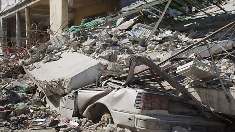
- Buildings are shaken and are either damaged or fall down completely.
- People are killed by falling debris in the streets, or in buildings if they are unable to get out in time, or may suffer injuries.
- Infrastructure including roads, railways, bridges, ports or airports can be damaged or destroyed.
- Electricity, gas and water supplies can be damaged or disrupted.
- Crops that are growing in fields are damaged as the soil heaves (moves upwards), pulling their roots out.
Secondary impacts
Secondary impacts occur in the hours, days or weeks after the earthquake.
- Aftershocks can damage or destroy buildings that have been weakened in the earthquake.
- When an earthquake occurs at sea, this can result in a tsunami that can cause flooding and damage along the coastline.
- Damaged gas and electricity supplies can cause fires.
- Damaged water supply, sanitation and sewerage pipes can cause diseases such as cholera.
- Damaged or destroyed schools, hospitals bring disruption to medical care and education.
- Destruction of factories, offices and other businesses can result in job losses and unemployment.
- Damage to crops can result in food shortages and hunger.
- Loss of businesses and costs of recovery can damage the economy.
Range of impacts from immediate to long term
1 of 5
Responses to earthquakes
The immediate response to an earthquake happens in the hours or first days after the earthquake.
Immediate aid focuses on rescue efforts and meeting basic needs:
- Warnings can be issued to alert people to possible danger from aftershocks or a tsunami.
- Fires need to be extinguished.
- Rescue efforts will try and find survivors who are trapped, or recover bodies.
- First aid and medical treatment are given to people who have been injured.
- Survivors need to be provided with food, water and shelter
- Dangerous buildings need to be made.
The long-term response takes place in the weeks, months or even years after an earthquake. It focuses on rebuilding, economic recovery and preparing for future earthquakes:
- Rebuilding or replacing destroyed homes
- Rebuiliding schools, hospitals, etc.
- Repairing damaged electricity, gas and water supply, and sewerage system.
- Repairing roads, railways and other infrastructure.
- Government investment or grants in the affected area.
- Changing building regulations and/or methods to better cope with earthquakes.
- Installing earthquake monitoring equipment to help predict future earthquakes
- Prepare people with earthquake drills, evacuation routes etc.
Methods of prediction and planning
Prediction and measurement of earthquakes
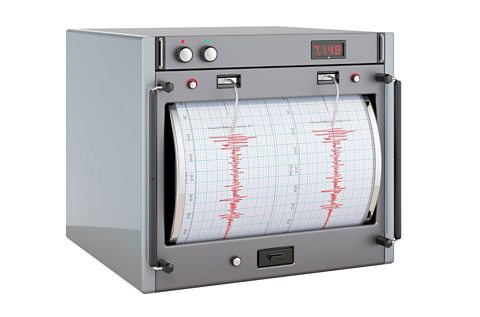
Earthquakes are extremely difficult to predict although scientists now know which areas have a higher risk and can identify How often and for how long an earthquake occurs. from previous earthquakes.
As a result, active earthquake zones are closely monitored for Earthquakes that happen as a result of tectonic plate movements. including the use of:
- tiltmeters, seismographs and laser equipment to measure earth movements
- sophisticated sound recording equipment to monitor earth tremors
The Richter magnitude scale
The Richter magnitude scale is used to measure the size of earthquakes. The higher the number, the more powerful the earthquake and the higher the chance that it will cause real damage.
| Number on Richter scale | How many happen in the world per year? | What does it mean? |
|---|---|---|
| 2.5 or less | Millions each year | Usually not felt, but some can be recorded by scientists |
| 2.5 to 5.4 | 500,000 per year | Often felt, but only causes minor damage |
| 5.5 to 6.0 | 1,000 per year | Can cause slight damage to buildings and other structures |
| 6.1 to 6.9 | 100 per year | May cause a lot of damage in very populated areas |
| 7.0 to 7.9 | 10-15 per year | Major earthquake and serious damage caused |
| 8.0 or greater | Once every year or two | This is a very large earthquake which can totally destroy large areas |
Source: USGHS/Modified Mercalli Intensity
Planning for earthquakes
Long term strategies are often expensive and more common in developed countries.
Constructing earthquake-proof buildings such as the Transamerica Pyramid in San Francisco which sways with the movement of the earth, has helped to reduce the damage caused by earthquakes. Constructing sea walls can also protect against tsunamis.
In regions with less money to invest in earthquake-resistant buildings and detection methods, the damage and impact is often worse.
Short term strategies include actions like practising earthquake drills - which some countries like Japan do as routinely as some places have fire drills.
In Japan, smartphones receive a warning alert of an earthquake. Emergency services practice evacuation scenarios and people know how and where to safely evacuate.
Despite all of these measures there were few warnings or successful predictions of the Indian Ocean tsunami. Most of the countries affected were developing countries without the funds for these sophisticated methods of detection.
They also lacked the improved communications which might have allowed them to evacuate coastal areas in time. The only warning they received was the retreat of sea water from beaches before the wave hit.
Householders in earthquake prone areas are encouraged to keep an emergency pack with food, water, blankets and medicines that they can grab quickly if an earthquake strikes.
Question
Give methods used to predict and plan for an earthquake.
Methods of prediction include:
- Tiltmetres and laser equipment are used to detect earth movements.
- Seismometers are used to record seismic activity and any increased activity allows experts to plan ahead.
- Sound recording equipment is used to monitor earth tremors.
- Scientists regularly monitor frequency patterns of seismic activity from previous earthquakes, to help them predict future earthquakes.
Methods of planning include:
- Local authorities have emergency plans in place for evacuation, search and rescue.
- Earthquake proof buildings which are designed to sway with the movement of the earth.
- In Japan, people receive a text message to warn them of an earthquake.
- Earthquake drills are regularly practiced to ensure people know how/where to evacuate.
- Emergency services practice evacuation scenarios in the event of an earthquake.
- Householders in earthquake prone areas are encouraged to keep an emergency pack with food, water, blankets and medicines that they can grab quickly if an earthquake strikes.
Case study: Haiti earthquake, 2021
Haiti is a lower middle-income country in the Caribbean. On 14th August 2021 a 7.2 earthquake struck the country.
The plate boundaries around Haiti are complex. The North American Plate lies to the north and the Caribbean Plate to the south. The earthquake took place at a conservative plate boundary, where the Caribbean plate moved eastwards.
The focus was only 10 km deep, and the epicentre was 125 km from the capital Port-au-Prince.
Effects
Primary impacts
- More than 2,000 people died and at least 12,000 were injured.
- Hospitals, schools and homes were destroyed.
Secondary impacts
- 332 people were still missing five days after the earthquake.
- Hundreds of landslides took place, which destroyed local ecosystems and habitats.
- Heavy rainfall from Tropical Storm Grace turned the landslides into mud and led to widespread flooding.
- A 3 m high tsunami was recorded around the capital, Port-au-Prince.
Responses
- The United Nations and charities, such as the Red Cross and CAFOD, sent aid. However, the delivery of essential supplies was hampered by heavy rains from Tropical Storm Grace.
- Temporary shelters were provided by the International Organization for Migration. These helped people who had lost their homes.
- The World Food Programme increased their provision of hot meals for school children. This helped to deal with food shortages.
- Temporary hospitals were constructed to help the injured. They also provided routine care, for example, some pregnant women gave birth safely within the temporary facilities.
- The estimated cost of damages from the earthquake is around US$1.6 billion. This amounts to 9.6 per cent of Haiti’s GDP.
Case study: Fukushima earthquake, 2022
Causes
Japan is a high income country in Asia. On 16th March 2022 a 7.3 earthquake struck the country. The plate boundaries around Japan are complex as the joining of four plates (the North America plate, Pacific plate, Philippine Sea plate, and Eurasian plate) and some microplates take place here. The earthquake happened along a destructive plate boundary, where the Pacific plate subducts. The focus was 41 km deep, and the epicentre was 57 km ENE of Namie, on the coast of Japan.
Effects
Primary impacts
- 4 people died and just over 247 were injured.
- 111 homes were destroyed.
- A bullet train was derailed. 75 passengers and three crew were trapped onboard, but there were no fatalities or injuries.
Secondary impacts
- Parts of the nearby Fukushima nuclear power plant were temporarily shut down , which led to power cuts.
- There was damage to roads, railway lines and other infrastructure. Some trains were cancelled.
- There was disruption to supply chains, which affected industries such as car and paper production.
Response
- Immediately after the earthquake, the Japanese authorities began to assess the damage.
- Electricity supplies were restored the following day.
- Over 227,000 separate insurance claims were made, amounting to over US$ 1 billion.
Take the National 5 Geography Earthquakes quiz
Recap
Earthquakes are mainly found on the boundaries of tectonic plates.
The main features of an earthquake are:
- fault line
- plate movement
- epicentre
- focus
- seismic waves
Earthquakes are caused by the sudden movement of tectonic plates which make up the Earth's crust.
Predicting earthquakes accurately remains challenging despite use of technology like:
- tiltmeters, seismographs and laser equipment monitor earth movements
- sound recording equipment to monitor earth tremors
Planning for earthquakes can be split into short and long term strategies:
- long term: constructing earthquake-proof buildings, sea walls - these are more expensive
- short term: practising earthquake drills, modern communication and warning systems, household survival kits
More on Environmental hazards
Find out more by working through a topic
- count1 of 3
- count2 of 3